Walkerville is a delightful small settlement on the eastern side of Waratah Bay, opposite Wilsons Promontory. With the exception of a few small beaches, much of the shoreline is fringed by rock shelf, consisting of steeply inclined rock layers. These layers and the limestone band above the present sea-level were the focus for this activity.
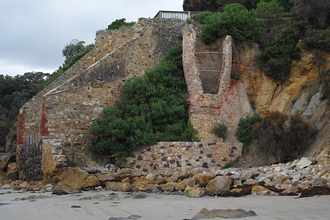
In the late 1800s limestone to make slaked lime was needed as a mortar for building with stone and brick in the rapidly growing Melbourne. The discovery of limestone full of calcite just above the sheltered cove of Walkerville South was ideal for this purpose. From 1870 to 1929 limestone was fired into slaked lime on the cliff face and transported in bags to Melbourne and Geelong. Many of the wharf pylons were still visible as recently as a few years back. A workers settlement here at one stage housed 80 workers and their families.
The stone was transported from the cliff side by horse drawn carriages/ trollies on rails. It was stacked into kilns between layers of wood; two of the kilns are still visible on the cliff face after much restoration work, despite vulnerability to the salt spray and weather generally. The kiln was then covered and fired – the resulting slaked lime was then bagged. Display boards included photographs of the kilns in working condition and of the village.
From the beach we looked up the cliff face to observe the distinct difference between the Pliocene upper level and the lower, darker Devonian period material. There were millions of years between these layers.
Strewn at the high tide level were limestone rocks which would not have been suitable for making lime.
Harley, ably assisted by Gary Wallis, pointed out the numerous mini fault lines in the large rocks. Much of this material had been almost turned into marble by metamorphism. Clearly much of this material was near the fault line which we viewed later around the headland. Apparently there were few fossils (needed to date the material) because they were destroyed by the faulting.
Around the headland, we observed fine material called pug near the fault line – this covered much of the surrounding sediments and limestone. After heavy rain the cliff may collapse, bringing down cliff-top vegetation, as seen in several places.
Further along the beach were some excellent examples of folding – anticlines and synclines. In places the folds were very tight, indicating that they were formed while the material was quite soft or pliable – perhaps from excessive heat.
It was pointed out that, east of Wilsons Prom, the coastal soils are calcite rich, whereas those to the west are rich in lime.
The rising tide prevented a return along the beach, so we walked back along a foot track, to the south of the lime kilns to see the greenstones surrounding part of one of the tidal islands. This dark brown (and in places quite green) rock looked as if made from liquid chocolate then twisted and turned! In places it was quite glossy, in others pitted. The cause – iron being leached out from the basalt from an earlier period. This greenstone is estimated to be about 550 m.y.a. in the case of the rock at the base of Bird Rock.
Jenny Porter
Blad Hill wetland.
ABN 23 918 778 150
Incorporation No A0044963D